Community Digital Plan
The pandemic crisis of 2020 has given us a moment to pause, reflect and consider new ways of thinking and planning. What has become clear is that a “digital experience and sense of place” will become more important than “conventional internet access and real-estate”.
Recently, Phil Myrick, the CEO of the Project for Public Spaces posted on LinkedIn, “to avoid a resurgence in infection and to recover equitably, cities must think more expansively about how all kinds of outdoor, everyday spaces can fulfill people’s daily needs, and work directly with the communities most affected by the virus and its economic fallout”.
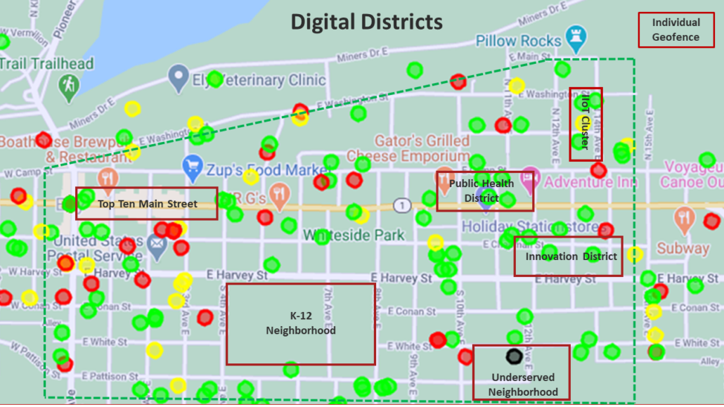
To fulfill the need for “new normal” public spaces, iNeighborhoods works with stakeholders and developers to plan for, and implement, a better community digital experience for a variety of public spaces including the disadvantaged community, Top Ten Main Streets, market areas, IoT clusters, innovation districts, K-12 schools, public health districts, technology or manufacturing corridors, or Geozones; an application enhanced digital service area defined by GIS coordinates.
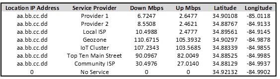
That said, iNeighborhoods cost effective Community Digital Plan makes use of specific GIS location, connectivity and community data, including wired and wireless connections, to capture performance and location data for every business and residential location in your area of interest. “No service” locations are also identified.
Community Digital Design
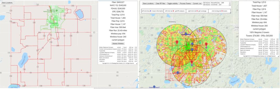
Need a configuration and cost estimate without the bother of a traditional feasibility study? iNeighborhoods will port your specific community data into our GIS based network design tool which will provide business model options and a cost estimate for hybrid fiber-wireless, wireless, IoT or Geozone digital community options. Our GIS based mapping and design process gives us the ability to provide you with cost effective design options at 10X less the cost in 10X less the amount of time.
Need to tell your story? iNeighborhoods will integrate your Community Digital Plan into an interactive-living GIS enabled Storymap. When integrated with other iNeighborhoods ecosystem development services or workshops, educational opportunities, ecosystem growth, revenue flows and social impact will be more effectively realized. In this way, stakeholders and developers can quickly evaluate cost-effective community digital plan options and have confidence in their sustainability, stakeholder and community impact.
For more information, please reach out to us HERE.